Rocher de Boule Property
|
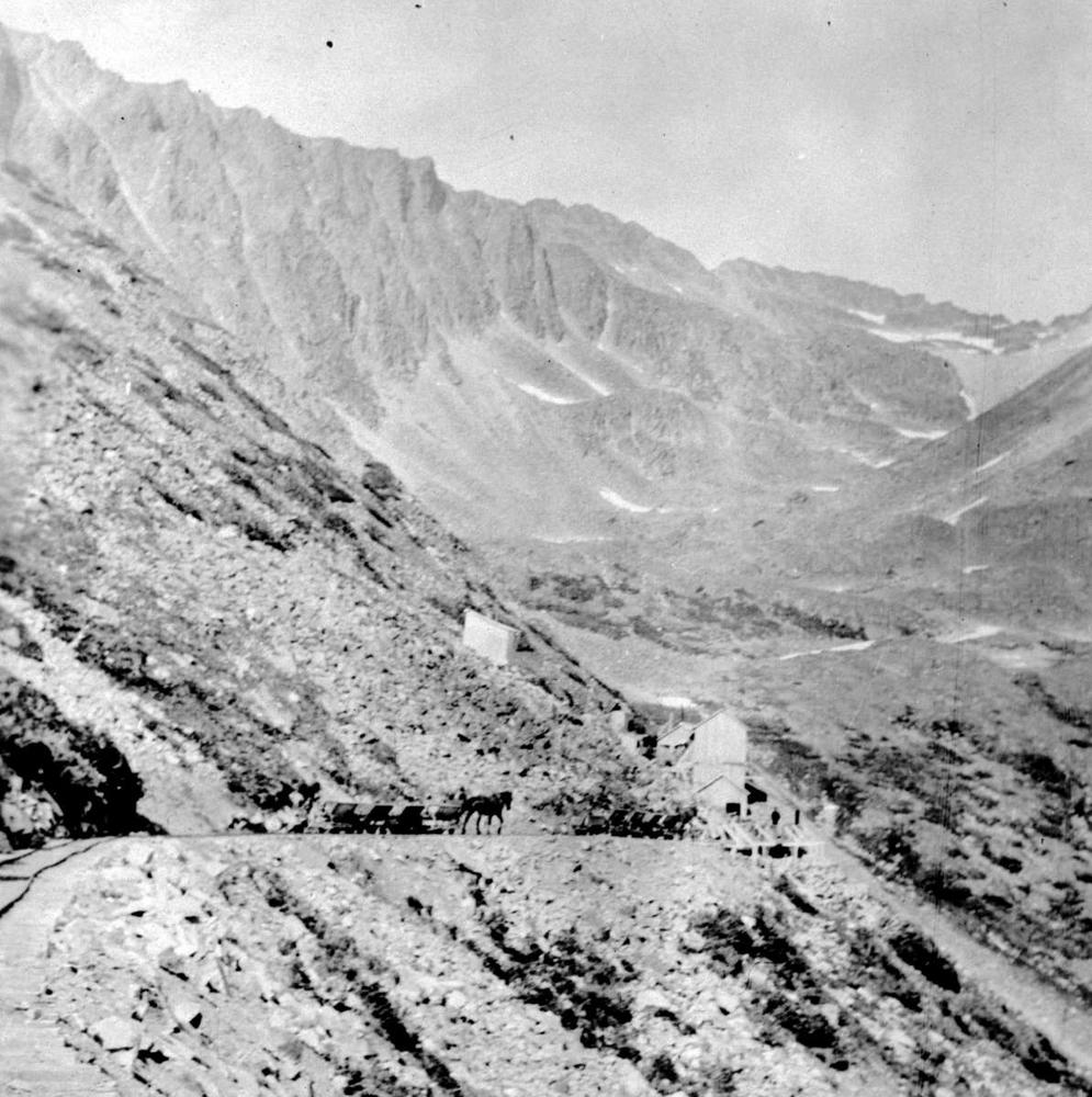
From the Omineca Miner September 2, 1911
Rocher De Boule Group Likely To Change Hands Most Important Transaction In Mining History of Omineca District Will Probably be Consummated Next Week - Property Has Fine Showings of Copper Ore On The Surface. "There are three veins on the group, The upper lead is four to eight feet wide and carries high grade "blue" copper ore. On the middle lead a fifty foot shaft and open cuts expose a four and a half foot vein of quartz, carrying grey copper and galena. The third vein is the widest and recent assays show it to carry high values. Along this vein replacement ore is found in the country rock, which is a diorite granite." |

|
|
From the MinFile 093M 071 detail report
WORK HISTORY The Rocher Deboule property was located in 1910 by Sargeant and Munroe of Hazelton, BC, which was acquired, in 1911, by Rocher Deboule Copper Company of Salt Lake City, Utah. Development on the property was done under lease by the Montana Continental Development Company, a company owned by the principals of Rocher Deboule Company. Ore was mined and shipped from the upper part of the Number 4 vein from April 1915, until February 1916, when the property reverted to its owners. Development work, previously neglected, was done on the Number 2 and 4 veins and by 1917 a 3100-foot (945 metres), known as the 1201, was driven from the bottom of the valley of Juniper Creek to intersect all known veins. Production in 1917-18 was largely from the Number 2 vein and was much less than in the previous two years, although the copper-gold grade was good. The mine was closed in October 1918, because of a lack of developed ore and a drop in copper price. |
|
|
EMPR ASS RPT
16575 - Geophysical Report on a Magnetic and VLF - Electromagnetic Survey for Southern Gold Resources LTD 1987 SUMMARY A magnetic and VLF-Electrcimagnetic survey was conducted across two portions of the Rocher Deboule properties by Southern Gold Resources Ltd, in the summer of 1987'. Past production of Cu, Au and Ag from mineralized veins located along the edge of a granodiorite intrusive generated renewed interest. in this area. It was the intention of this survey to assist the mapping of the intrusive/sedimentary contact and identify specific targets for ground investigations |
EMPR ASS RPT
16714 - Summary Report - Southern Gold Resources LTD 1987 The history of the Rocher Deboule Mines is extensively covered in provincial publications (eg Kindle 1954, Sutherland Brown 1960, etc.) and is summarized in detail by Woodcock (1987) in his engineering report on the property to accompany Southern Gold Resources Prospectus. However, in brief, there are six principal vein structures on the property all of which have seen limited development. The 1987 field season on the Rocher Deboule property has been successful in indicating a significant potential for precious metal vein deposits. This potential lies on dip and strike extensions of the well explored #2 and #4 veins and on the relatively unexplored #1, #2a and #3 veins. |
Recorded Production From 16714 Report page 8
Year |
Tons |
Gold oz |
Silver Oz |
Copper lb |
1915 |
17,000 |
1,418 |
21,893 |
2,788,000 |
1916 |
16,760 |
1,184 |
16,738 |
1,753,225 |
1917 |
2,889 |
781 |
7,987 |
714,871 |
1918 |
3,184 |
832 |
16,247 |
635,870 |
1929 |
72 |
10 |
2,972 |
6,120 |
1952 |
12,814 |
267 |
8,640 |
305,498 |
Total |
Value |
|
EMPR ASS RPT
25674 - Prospecting Report 1998 Summary The property has been the subject of sporadic activity since the discovery of high grade copper veins in 1910 by local prospectors. The property hosts a number of occurrences the most significant being the Rocher DeBoule mine, the Victoria mine, the Highland Boy and the Great Ohio. The Rocher DeBoule mine produced principally from two veins, the NO.2 and the NO.4 Total production was approximately 53,000 tons grading 0.0982 ounces per ton gold, 1.6 ounces per ton silver and 2.69% copper (Gunning, 1998). Limited production of approximately 90 tons from the Victoria mine and 75 tons from the Highland Boy was also reported (BCDM Bulletin #43). Exploration work in the region has historically concentrated on vein mineralization associated with the Rocher DeBoule stock, however reference has also been made to the property’s possible bulk tonnage potential (Stockwatch, November 22, 1990). Exploration potential of the property is considered to be excellent with the possibility to discover additional resources in the immediate vicinity of the old workings and elsewhere on the mineral claim. |
EMPR ASS RPT
26984 - Geological and Geochemical Report on the RD 1-6 Claim Group for Amaris.empr.gov.bc.ca/ArisReports/26984.PDFeridex Minerals Corp 2002\ This report was prepared at the request of Ameridex Minerals Corp. to describe and evaluate the results of geological mapping, rock chip sampling, and stream sediment sampling carried out on the Rocher Deboule and Victoria mineral occurrences, located approximately 55 km. northwest of Smithers, B.C., within the Omenica Mining Division Based on the targets outhned in this sampling program, a series of diamond drill holes are proposed to test the depth extension of known surface mineralization. Concurrent with diamond drilling, a program of hand trenching, geological mapping and rock chip sampling is required to outline further extensions of known mineral trends and new zones |
|
EMPR ASS RPT
27558 - Geological and geochecmical report on the RD 1-8 Claim Group for Ameridex Minerals Corp 2004 Based on the targets outlined in this sampling program, a series of diamond drill holes are proposed to test the depth extension of known surface mineralization. Concurrent with diamond drilling, a program of hand trenching, geological mapping and rock chip sampling is required to outline fbrther extensions of known mineral trends and new zones. |
EMPR ASS RPT
28625 Assessment Report On Exploration Activities 2006 In 2006 prospecting and GPS surveys were carried out for the purpose of assessing and accurately mapping zones of mineralization on the property. Assays reported up to 8% copper, 20 g/t gold and 124 g/t silver values on the property. |
|
EMPR ASS RPT
29338 - Technical Report 2007 (Part 1) Part 2 The economic potential and Property merit is to be found not only in the historical quartzsulphide veins but also in mineralization and alteration that has copper-gold porphyry and/ or iron oxide-copper-gold (IOCG) affinities and potential. It must be stressed that the vein systems known on the Rocher Deboule Property could be part of a much larger hydrothermal system that are indicative of a porphyry copper (gold) system laterally or possibly at depth. Hydrothermal vein systems, like Rocher Deboule, can be outboard of a typical hydrothermally altered defined porphyry copper (gold) system. |
EMPR ASS RPT
33297 - Prospecting and Geochemical Report for American Manganese Inc 2011 The results show that there is considerably more surface mineralization than was previously thought; there is greater continuity between the veins than previously realized and that the vein system as a whole is strongly zoned. The property appears to be underlain by a broad, east to west trending belt of alteration zones and/or intermittent mineralization that may reflect the presence of one or more buried intrusion feeding fluid into a copper and gold-rich stockwork between the Rocher Deboule and Highland Boy adits. It also suggests that the magnetite and nickel-cobalt arsenide mineralization found at Victoria and elsewhere may be partially formed through mobilization of elements within the host stock, and that lead and zinc sulphides are restricted to the periphery of the stock |
The Rocher Deboule Property is currently held by American Manganese
American Manganese Inc. has implemented a two-pronged exploration approach on its multi mineral 997.76 hectares (2,565 acres) gold/silver/copper/cobalt/ tungsten property located 8 km south of New Hazelton, BC.
The Rocher Deboule property is part of the Hazelton Project, which includes 3 historic mines: